Home

East Melbourne Historical Society

Drop-down menu

  • Articles
  • People
    • Notable Women
    • WW1 soldiers and nurses
    • WW1 nurses
  • History
    • Milestones
    • Buildings
    • Community
    • People
  • Gallery
    • Maps
    • MMBW plans
    • Abortion battles
    • Bishopscourt
    • Bishopscourt garden
    • Bomb shelter
    • Buildings
    • Cairns Memorial Church
    • Early Melbourne
    • Football
    • Jean Campbell
    • Lanes
    • Margaret McLean
      • Family and home
      • Female suffrage
      • Clippings - Australia
      • Clippings - Britain
      • Clippings - USA
    • Personalities
    • Yarra Park
      • History
      • Desecration
    • Yarra River
  • Catalogue
    • Browse and Search
    • Catalogue table view
    • Site images
  • Images
  • Society
    • Activities
    • Newsletters
    • Tributes
      • John Barrie Wykes
      • Wynne McGrath
    • Publications
      • Heritage Matters
      • What's in a Name
    • About
Home
    • Home
    • Search
    • Forum
    • Contact

1857 Bradshaw's map of Melbourne & suburbs

Subjects

  • Maps
  • Plans
  • first
  • ‹ previous
  • 2051 of 2369
  • next ›
  • last
Image
Move your mouse over image or click to enlarge
Acquisition number: 
1565
Catalogue number: 
emdf0352
File name: 
DF0352
File location: 
Digital archive

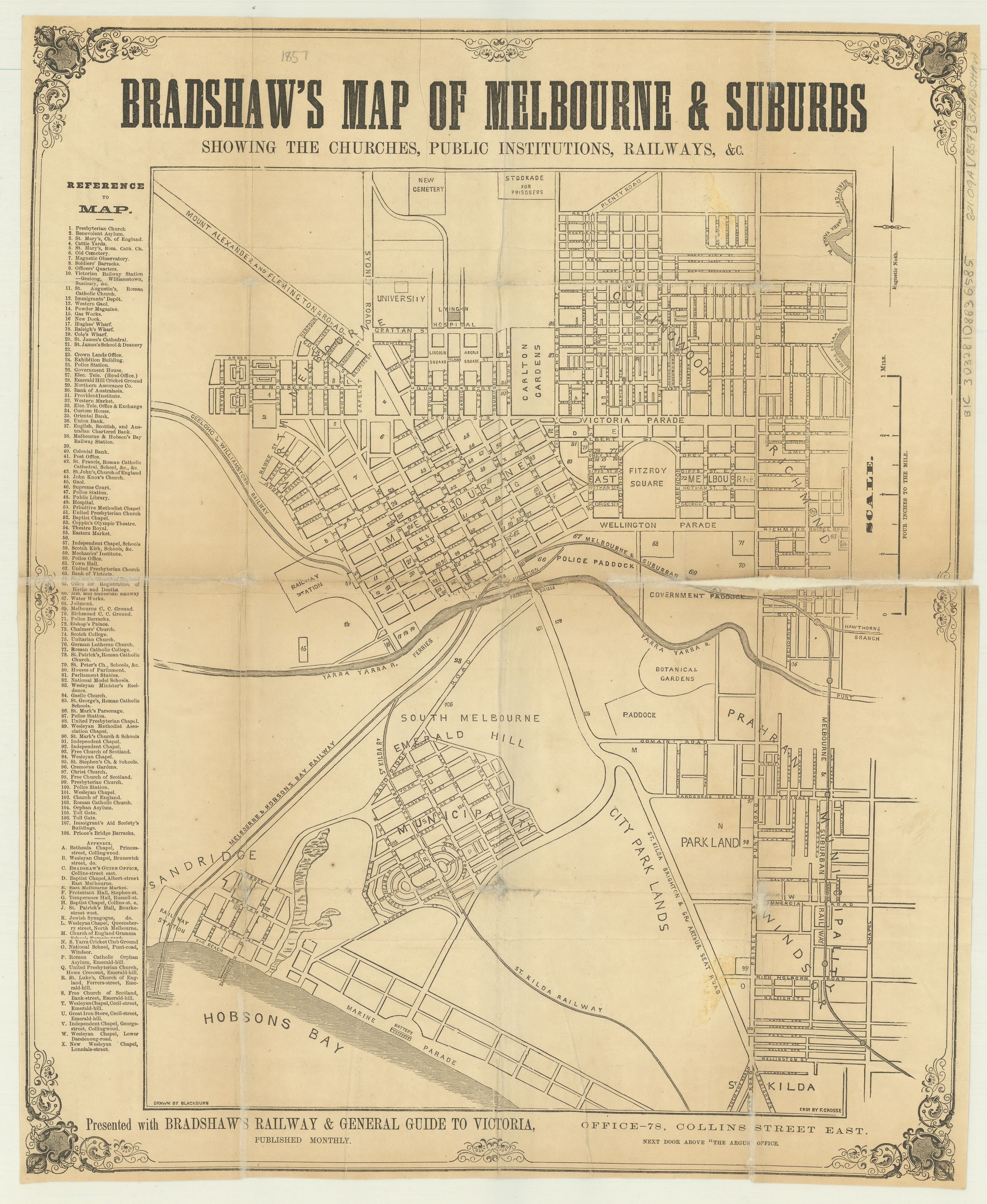
A map of Melbourne and suburbs, with streets named and churches and public institutions marked.

The original map is in the collection of the State Library of Victoria and its record reads as follows:

Title: Bradshaw's map of Melbourne & suburbs [cartographic material] : showing the churches, public institutions, railways, &c. / drawn by Blackburn ; engd. by F. Grosse.
Author/Creator: Bradshaw (Firm)
Contributor(s): Frederick Grosse 1828-1894.; Blackburn
Publisher: Melbourne : Bradshaw, Office-78, Collins St. East, next door above "The Argus" Office 
Date(s): 1857?] 
Description: 1 map ; 40 x 34 cm., on sheet 49 x 40 cm. 
Copyright status: This work is out of copyright 
Terms of use: No copyright restrictions apply. 
Map data: Scale [1:15 840]. 4 inches to the mile 
Subjects: Streets -- Victoria -- Melbourne -- Maps; Melbourne (Vic.) -- Maps
Notes: Street map of the City of Melbourne showing street names, buildings, railways, parks and drainage. At right of map is a detailed index entitled Reference to Map and listing all placenames and buildings, including an appendix listing all churches. 
"Presented with Bradshaw's Railway & general guide to Victoria, published monthly". 
Other title(s): Map of Melbourne and suburbs 
Bradshaw's Railway & general guide to Victoria 
Link to digitised item: http://handle.slv.vic.gov.au/10381/170317 
Link to this record: http://search.slv.vic.gov.au/primo_library/libweb/action/dlDisplay.do?vi...

Item type: 
Map
Date of publication or creation: 
1857
Publisher: 
Bradshaw
Owner of original: 
State Library of Victoria
  • 2808 reads
  • Share this
  • PrintPrint
  • EmailEmail

User login

  • Join EMHS
  • Request new password
  • Privacy
  • Membership
  • About
  • Contact
  • Guidelines