Home

East Melbourne Historical Society

Drop-down menu

  • Articles
  • People
    • Notable Women
    • WW1 soldiers and nurses
    • WW1 nurses
  • History
    • Milestones
    • Buildings
    • Community
    • People
  • Gallery
    • Maps
    • MMBW plans
    • Abortion battles
    • Bishopscourt
    • Bishopscourt garden
    • Bomb shelter
    • Buildings
    • Cairns Memorial Church
    • Early Melbourne
    • Football
    • Jean Campbell
    • Lanes
    • Margaret McLean
      • Family and home
      • Female suffrage
      • Clippings - Australia
      • Clippings - Britain
      • Clippings - USA
    • Personalities
    • Yarra Park
      • History
      • Desecration
    • Yarra River
  • Catalogue
    • Browse and Search
    • Catalogue table view
    • Site images
  • Images
  • Society
    • Activities
    • Newsletters
    • Tributes
      • John Barrie Wykes
      • Wynne McGrath
    • Publications
      • Heritage Matters
      • What's in a Name
    • About
Home
    • Home
    • Search
    • Forum
    • Contact

1859 Geological Survey Map

Subjects

  • Maps
  • Plans
  • first
  • ‹ previous
  • 2050 of 2369
  • next ›
  • last
Image
Move your mouse over image or click to enlarge
Acquisition number: 
1564
Catalogue number: 
emdf0351
File name: 
DF0351
File location: 
Digital archive

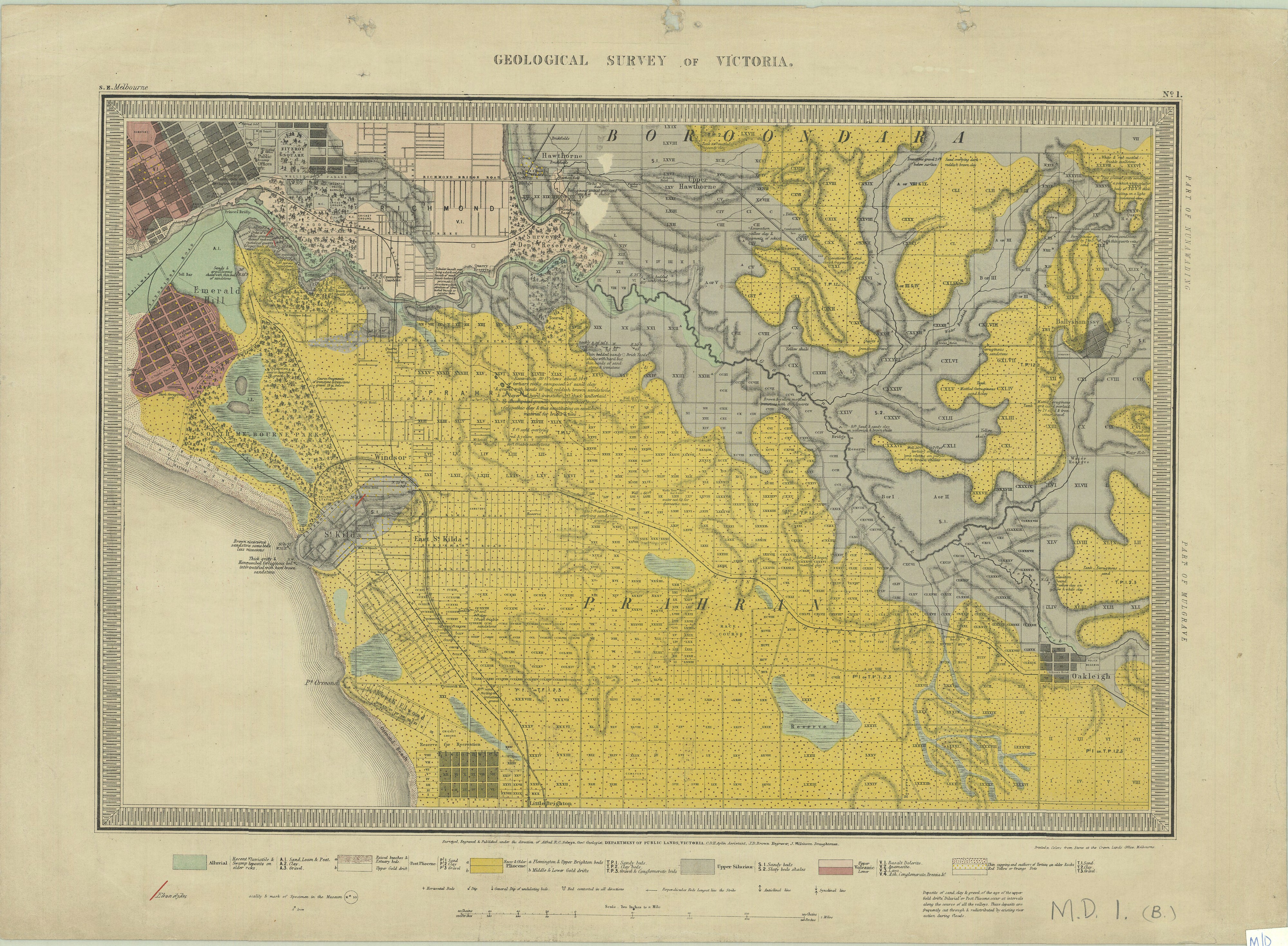
The map shows the central city grid and suburbs to the south and east, including East Melbourne. The caption beneath the map reads 'Surveyed, Engraved & Published under the direction of Alfred R C Selwyn, Govt Geologist'.

As well as geological information the map provides physical information and information on the early development of Melbourne and suburbs.  In this map the area of East Melbourne which on earlier maps was named the Government Paddock, with the Police Paddock adjacent to the west, has now itself become the Police Paddock, with the adjacent paddock un-named.  The Mounted Police Barracks, established after separation and replacing the earlier barracks to the south-west of the paddock, are marked in the north-east corner.  The Melbourne Cricket Ground and the Richmond Cricket Ground are also shown.  Governor C J LaTrobe's hill-top site for his home, 'Jolimont', is clearly depicted although not named.

The original map is in the collection of the Public Records Office of Victoria, in its Historic Plan Collection. Surveyor-general's department: VPRS 8168/P5 Item MD, record 1B
Search term: MD 1B: BOROONDARRA PRAHRAN MELBOURNE SOUTH

Item type: 
Map
External reference: 
Public Records Office: Historic plans collection
Date of publication or creation: 
1859
Publisher: 
The Department of Crown Lands and Survey Melbourne
Owner of original: 
Public Records Office of Victoria
  • 2731 reads
  • Share this
  • PrintPrint
  • EmailEmail

User login

  • Join EMHS
  • Request new password
  • Privacy
  • Membership
  • About
  • Contact
  • Guidelines