Home

East Melbourne Historical Society

Drop-down menu

  • Articles
  • People
    • Notable Women
    • WW1 soldiers and nurses
    • WW1 nurses
  • History
    • Milestones
    • Buildings
    • Community
    • People
  • Gallery
    • Maps
    • MMBW plans
    • Abortion battles
    • Bishopscourt
    • Bishopscourt garden
    • Bomb shelter
    • Buildings
    • Cairns Memorial Church
    • Early Melbourne
    • Football
    • Jean Campbell
    • Lanes
    • Margaret McLean
      • Family and home
      • Female suffrage
      • Clippings - Australia
      • Clippings - Britain
      • Clippings - USA
    • Personalities
    • Yarra Park
      • History
      • Desecration
    • Yarra River
  • Catalogue
    • Browse and Search
    • Catalogue table view
    • Site images
  • Images
  • Society
    • Activities
    • Newsletters
    • Tributes
      • John Barrie Wykes
      • Wynne McGrath
    • Publications
      • Heritage Matters
      • What's in a Name
    • About
Home
    • Home
    • Search
    • Forum
    • Contact

Sketch map of Melbourne by Charles Joseph La Trobe, c.1840

Subjects

  • Mounted police
  • Native police
  • Police
  • first
  • ‹ previous
  • 2362 of 2366
  • next ›
  • last
Image
Move your mouse over image or click to enlarge
Acquisition number: 
1784
Catalogue number: 
emdf0482
File name: 
DF0482
File location: 
Digital archive

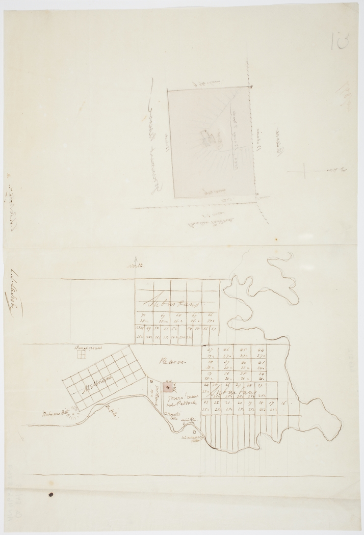
This sketch map by Charles Joseph La Trobe marks in pink his own estate known as Jolimont. Directly south, on the river, is the site of the Mounted Police.  Further to the east, on the other side of the bend now straightened, is the site of the Native Police.  Further to the east again, and on the south side of the river is the Aboriginal Mission Station.  Other points of interest are Batman's Hill and the old Burial Ground. 

The original is in the collection of the State Library of NSW, details below:-

[Sketch plan and map showing Melbourne and detail of block of land adjacent to Government reserve]
COPYRIGHT AND PERMISSIONS:
This image may be used freely without requesting permission. Please acknowledge that the image is from the collections of the State Library of New South Wales.
CALL NUMBER:  D Ca 84/23  [Dixson Map Collection (Z/Ca84/23)]
IE NUMBER: IE3763892
FILE NUMBER: FL3763903
FILE TITLE:
[Sketch plan and map showing Melbourne and detail of block of land adjacent to Government reserve] [cartographic material] / C.J. La Trobe. [Album view] 1840

Search under ‘Charles Joseph La Trobe’ and filter by Maps


Item type: 
Map
History of item: 

Thanks to Marie Fels who located this item.

Permission reference: 
State Library of New South Wales
  • 271 reads
  • Share this
  • PrintPrint
  • EmailEmail

User login

  • Join EMHS
  • Request new password
  • Privacy
  • Membership
  • About
  • Contact
  • Guidelines