Home

East Melbourne Historical Society

Drop-down menu

  • Articles
  • People
    • Notable Women
    • WW1 soldiers and nurses
    • WW1 nurses
  • History
    • Milestones
    • Buildings
    • Community
    • People
  • Gallery
    • Maps
    • MMBW plans
    • Abortion battles
    • Bishopscourt
    • Bishopscourt garden
    • Bomb shelter
    • Buildings
    • Cairns Memorial Church
    • Early Melbourne
    • Football
    • Jean Campbell
    • Lanes
    • Margaret McLean
      • Family and home
      • Female suffrage
      • Clippings - Australia
      • Clippings - Britain
      • Clippings - USA
    • Personalities
    • Yarra Park
      • History
      • Desecration
    • Yarra River
  • Catalogue
    • Browse and Search
    • Catalogue table view
    • Site images
  • Images
  • Society
    • Activities
    • Newsletters
    • Tributes
      • John Barrie Wykes
      • Wynne McGrath
    • Publications
      • Heritage Matters
      • What's in a Name
    • About
Home
    • Home
    • Search
    • Forum
    • Contact

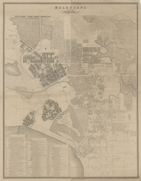
Map of Melbourne and its Suburbs - 1855

  • first
  • ‹ previous
  • 1340 of 2369
  • next ›
  • last
Image
Move your mouse over image or click to enlarge
Acquisition number: 
857
Catalogue number: 
emdf0049
File name: 
DF0049
File location: 
Digital file

Detailed map of Melbourne and suburbs in 1855. It extends from Northcote in the north to St Kilda in the south and from North and South Melbourne in the west to Studley Park in the east.

Item type: 
Map
External reference: 
State Library of Victoria: Images
External reference: 
State Library of Victoria: Catalogue record
Item size: 
100x120cm
Item inscription: 

Compiled by James Kearney, Draughtsman. Engraved by David Tulloch and James D. Brown. Captain Andrew Clarke R.E., Surveyor General. 1855

Author: 
James Kearney
Author: 
David Tulloch
Author: 
James D. Brown
Date of publication or creation: 
1855
Publisher: 
Surveyor General
History of item: 

Obtained from the State Library of Victoria where it is in the form of one map on four sheets each mounted on heavy card. The image shown here has been compiled from four digital images published by the State Library of Victoria.

SLV Citation:
Brown, J. D., Kearney, J., & Tulloch, D. (1855). Melbourne and its suburbs [cartographic material] / compiled by James Kearney, draughtsman ; engraved by David Tulloch and James D. Brown. [Melbourne]: Andrew Clarke, Surveyor General.
 

Owner of original: 
State Library of Victoria
Copyright owner: 
Out of copyright
Reproduction rights: 
State Library of Victoria
Year acquired: 
2011
  • 13287 reads
  • Share this
  • PrintPrint
  • EmailEmail

User login

  • Join EMHS
  • Request new password
  • Privacy
  • Membership
  • About
  • Contact
  • Guidelines